Drones + AI: A faster, safer path to clearing land mines
Antipersonnel land mines remain active in at least 57 countries. In 2024, 1,945 people were killed and 4,325 were injured; about 90% were civilians, and nearly half were children. Demining teams cleared 105,640 mines in the same period, yet new conflicts keep adding more. For families returning home and farmers stepping back into their fields, one wrong footstep can change a life forever.
The problem with ground-only detection
Handheld metal detectors struggle in mineral-rich soils and with low-metal or plastic mines. Ground-penetrating radar has trouble in wet, uneven, or vegetated terrain and can trigger many false alarms. Manual probing and trained animals work, but they're slow, require significant resources, and put people at risk. At the scale seen in places like Ukraine, ground surveys alone can't keep up.
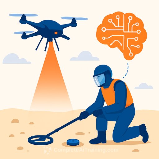
What aerial sensing adds
Drone-based surveys speed up coverage and keep people at a safer distance, especially for mines on or near the surface. In controlled tests, drone-mounted magnetic sensing detected metallic targets with accuracy comparable to ground-based methods, cut human exposure, and increased survey speed by roughly 10x.
The real gains come from combining multiple sensors. Each sees different clues:
- RGB cameras: visual shape, color, context
- Thermal: temperature differences between mines and soil
- Multispectral/hyperspectral: material signatures and subtle surface changes
- Synthetic-aperture radar (SAR): surface/structure variations under vegetation
- LiDAR: fine-grained elevation and surface disturbance
- Magnetometers and electromagnetic induction: underground metallic components
Fusing these views improves detection across mine types, soils, and seasons where any single sensor can fail.
The missing piece: shared, realistic datasets
Despite strong potential, multisensor drone systems are still underused. A key blocker is the lack of public benchmark datasets that include multiple sensors, realistic mine placements, and precise ground truth. Without them, it's hard to compare algorithms, validate claims, or train AI models that hold up outside a test range.
Building open multisensor benchmarks
To close that gap, a research team partnered with the nonprofit Demining Research Community to collect a comprehensive dataset at a controlled test field in Oklahoma. Over 140 inert land-mine and unexploded-ordnance targets were deployed. Data was captured on ground and by drone at multiple altitudes using hyperspectral, multispectral, thermal, RGB, LiDAR, SAR, ground-penetrating radar, electromagnetic induction, and magnetometers. A subset-visible and near-infrared hyperspectral data at 20 meters-has been publicly released via a conference publication, with broader releases planned through a forthcoming journal publication.
The effort expanded internationally with the Royal Military Academy of Belgium. Teams deployed more than 110 replicas of PFM-1 mines across varied terrain and vegetation to simulate aerial dispersal. Every mine was precisely geolocated with GPS base stations. Drones flew multiple altitudes with hyperspectral, multispectral, thermal, RGB, LiDAR, and polarization sensors to cut glare. Additional research groups and industry partners collected compatible datasets over the same field. These collections are being processed for open access.
To our knowledge, these will be the first public, multisensor, multi-altitude benchmarks of this kind for mine detection and broader remote sensing research. They enable fair comparisons, realistic stress tests, and more dependable AI development.
Reliability matters as much as accuracy
In mine action, one wrong call can be fatal. Beyond raw detection scores, the focus is shifting to AI that can express uncertainty. Instead of forcing a confident prediction, models can output "I'm not sure" with an uncertainty score tied to noisy or ambiguous inputs. This helps operators prioritize follow-up checks, plan ground verification, and make safer decisions in tough conditions.
What this enables for demining teams
- Faster area surveys with less human exposure
- Cross-checking detections across sensors to lower false alarms
- Uncertainty-aware triage to focus scarce ground resources
- Better handoffs between aerial scans and ground teams
- More consistent results across terrain, seasons, and mine types
Why it matters
This work isn't about drones or algorithms for their own sake. It's about farmers safely reclaiming fields, children walking to school without fear, and communities rebuilding with confidence. Open datasets, sensor fusion, and uncertainty-aware AI move demining toward a process that's safer, smarter, and scalable.
Further context
- Landmine Monitor 2024 for global casualty and clearance trends
- GICHD: Land release methods for best practices in survey and clearance
For researchers and safety leaders
- AI for Science & Research for methods, tooling, and case studies on building dependable models
- AI Learning Path for Safety Engineers for uncertainty-aware detection, risk assessment, and safety-critical deployment
Your membership also unlocks: