MCP server · Analytics
GeoServer MCP server
by mahdin75
Lets your AI look at and manage map data in your GeoServer, like layers, workspaces and styles.
This is a small helper that connects your AI assistant to GeoServer, the program many teams use to publish maps and location data. Once it is set up, you can ask your AI about your map layers in normal words instead of clicking around the GeoServer admin pages. It is handy for anyone who works with maps, addresses, or location data and already has a GeoServer running.
What is an MCP server? The 30-second version
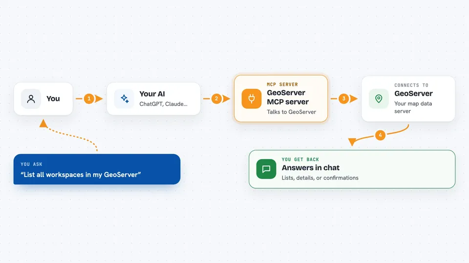
On its own, your AI can only chat with you. An MCP server is a small helper program that gives your AI a new skill, in this case a connection to your GeoServer. You install this helper, tell it where your GeoServer lives and how to log in, and then your AI can look things up or make changes there when you ask. You never touch the helper directly; your AI calls it for you.
What this MCP server does
You ask your AI something about your map data, like which layers exist or what is inside one layer. The AI passes that request to this helper program. The helper then talks to your GeoServer through its REST API, which is just the official way programs ask GeoServer for things. GeoServer sends back the answer, and the helper hands it to your AI, which explains it to you in the chat. For some tasks, like creating a workspace or uploading a shapefile, the helper also makes the change in GeoServer for you.
 Click to zoom
What you can do with it
- List the workspaces and layers in your GeoServer
- Get details about one specific layer
- Create a new workspace or datastore
- Upload a shapefile or GeoPackage as a new datastore
- Query features inside a layer
- Generate a map image from your data
- Delete a resource or coveragestore
Try asking your AI
- “List all the workspaces in my GeoServer.”
- “What layers are in the workspace called demo?”
- “Show me the details of the layer roads in the demo workspace.”
- “Create a new workspace called test_project.”
What it gives back to you
You get answers in plain chat text: lists of names, details about a layer, or a short confirmation that something was created or deleted. When you ask for a map or a query, you get back the result, like an image or a set of features. It does not dump raw technical output on you unless you ask for it.
Before you start
What you need
- A running GeoServer instance with its REST API turned on
- The web address of your GeoServer, like http://localhost:8080/geoserver
- A GeoServer username and password
- Python 3.10 or newer if you install it with pip, or Docker if you use the Docker version
Good to know
This helper can create and delete things in your GeoServer, so be careful with delete requests and check before you confirm them.
Install it with your AI
Add GeoServer MCP server to your AI, no technical skills needed
You don't install anything by hand. You copy one prompt, paste it into an AI that can work on your computer, and it checks, installs and connects the server for you, asking you when it needs something.
Sign in to get the install prompt
Members get a ready-made prompt that lets the Claude desktop app check GeoServer MCP server, install it and connect it for them, step by step. You don't need any technical skills: you copy, paste and answer a few questions. Your connected AI can also find and install any of the 4,361 MCP servers here for you.
Who it's for
People who work with maps and location data, like GIS analysts, data managers, and anyone who already runs a GeoServer and wants to ask questions about it in plain language.