MCP server · Analytics · official
GeoLens MCP server
by geolens-io · official
Let your AI search your GeoLens map catalog, read dataset details, and run safe read-only map queries.
This is a small helper that connects your AI assistant to a GeoLens map catalog. GeoLens is a place where map data and saved maps live, and this helper lets your AI look things up there for you. It is handy if you work with location data and want answers without clicking around a map site.
What is an MCP server? The 30-second version
On its own, your AI can only chat with you. An MCP server is a small helper program that gives your AI a new skill or a connection to another app. This one connects your AI to a GeoLens instance, so it can search datasets, read map details, and run simple read-only queries when you ask. You set it up once, and after that your AI just uses it quietly in the background.
What this MCP server does
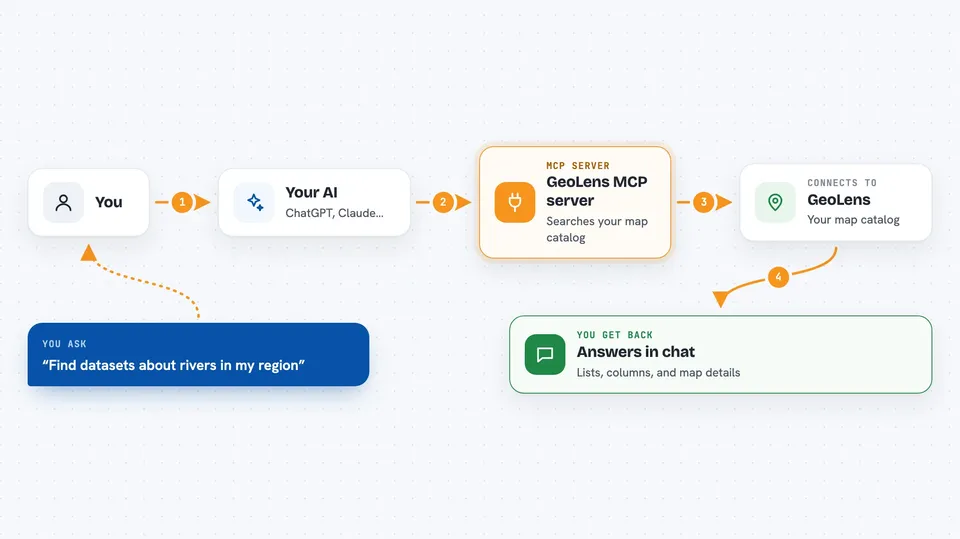
You ask your AI something about your map data. The AI passes your question to this helper. The helper talks to your GeoLens instance using the address and key you gave it. GeoLens sends back the matching datasets, columns, map details, or query results. Your AI then explains what it found in plain words in the chat.
 Click to zoom
What you can do with it
- Search your GeoLens catalog by keyword
- Look up a dataset's columns, geometry type, and feature count
- Read a sample of map features as GeoJSON
- List your saved maps and their layers
- Open one saved map's full details and view settings
- Run a simple read-only SQL query over your data tables
Try asking your AI
- “Search GeoLens for datasets about rivers in my region”
- “What columns does the parcels dataset have, and how many features are in it?”
- “Show me the first few features from the roads dataset”
- “List my saved maps and tell me which one has the most layers”
What it gives back to you
You get answers in the chat, not files to download. Searches come back as a list of matching datasets with short details. Schema lookups return column names, geometry type, feature count, and extent. Feature reads return a small set of map points or shapes, and queries return rows of numbers or text. Everything is read-only, so nothing in your catalog changes.
Before you start
What you need
- A GeoLens instance address (the web address of your GeoLens site)
- An API key from GeoLens, made in Settings then API keys (a kind of password for apps)
- Python installed on your computer, plus the uvx or pip tool to run the helper
- An MCP-capable AI app, such as Claude Code or Cursor
Good to know
It is read-only by design, so it cannot change or delete your data, but the query tool can still read whatever your API key is allowed to see, so use a key with the right access.
Install it with your AI
Add GeoLens MCP server to your AI, no technical skills needed
You don't install anything by hand. You copy one prompt, paste it into an AI that can work on your computer, and it checks, installs and connects the server for you, asking you when it needs something.
Sign in to get the install prompt
Members get a ready-made prompt that lets the Claude desktop app check GeoLens MCP server, install it and connect it for them, step by step. You don't need any technical skills: you copy, paste and answer a few questions. Your connected AI can also find and install any of the 4,361 MCP servers here for you.
Who it's for
People who work with map or location data and already use a GeoLens instance, such as GIS analysts, planners, and data teams.