MCP server · Privacy
ArcGIS Pro MCP bridge
by muend
Lets your AI run ArcGIS Pro geoprocessing tasks on your own Windows machine, safely.
This is a small helper program that connects your AI assistant to ArcGIS Pro on your Windows computer. Once it is set up, you can ask your AI in plain words to buffer, project, dissolve, or analyze your GIS data, and it will run the real ArcGIS tools for you. It is made for GIS analysts and map makers who already use ArcGIS Pro and want to save clicks.
What is an MCP server? The 30-second version
On its own, your AI can only chat. An MCP server is a little helper program that gives your AI a new skill or a connection to an app. This one connects your AI to ArcGIS Pro and its ArcPy engine, so the AI can look things up and run geoprocessing on your data when you ask. You keep working in ArcGIS Pro; the AI just does the button pushing.
What this MCP server does
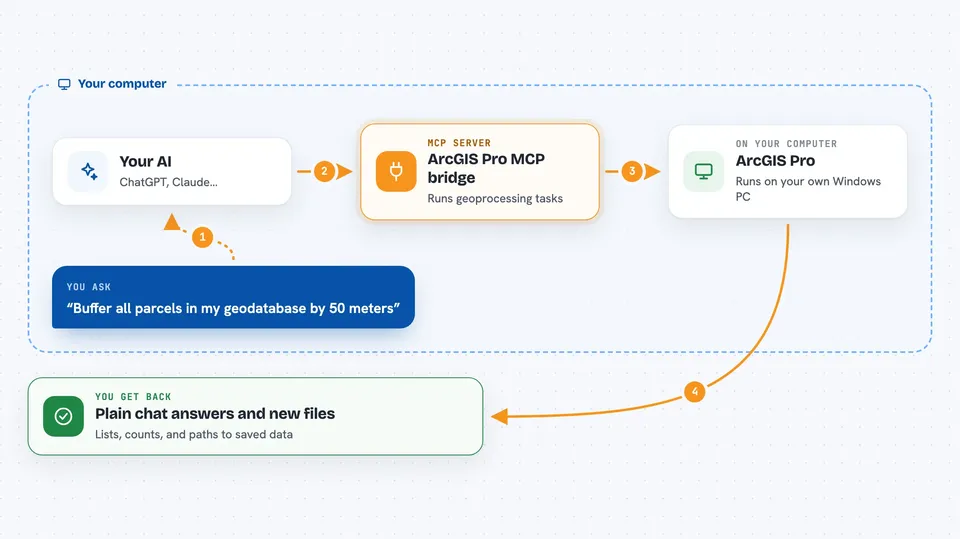
You type a request in plain words, like buffering parcels or listing layers in a geodatabase. Your AI sends that request to this helper program running quietly on your PC. The helper starts a separate worker process that talks to ArcGIS Pro's ArcPy engine, runs the geoprocessing, and sends the result back. Your AI then tells you what happened, in normal chat language. Everything stays on your machine and inside folders you have allowed.
 Click to zoom
What you can do with it
- Buffer, dissolve, and overlay feature layers
- List and describe feature classes inside a geodatabase
- Project data to a different coordinate system
- Calculate slope, aspect, or hillshade from a DEM
- Run kernel density or hot spot analysis on points
- Export a map layout to PDF or PNG
- Check and repair geometry errors in your data
Try asking your AI
- “Buffer all parcels in my geodatabase by 50 meters and save to scratch.”
- “List all feature classes in C:\GIS\city.gdb starting with road_.”
- “Dissolve the neighborhoods layer by district_id.”
- “Calculate slope and aspect from the DEM at C:\GIS\dem.tif.”
What it gives back to you
You get back short, readable answers in the chat: lists of layers, counts of features, success or failure messages, and sometimes a path to a new file it created. If something goes wrong, it explains the error in plain words instead of crashing. It can also report where a new dataset was saved so you can open it in ArcGIS Pro.
Before you start
What you need
- A Windows PC with a licensed ArcGIS Pro installation
- Python 3.11 or newer for the bridge package
- A folder you allow it to read and write in
- A file geodatabase for scratch work
Good to know
Some tools can change or delete your data, so they only run when you clearly confirm, and it can only touch folders you have allowed.
Install it with your AI
Add ArcGIS Pro MCP bridge to your AI, no technical skills needed
You don't install anything by hand. You copy one prompt, paste it into an AI that can work on your computer, and it checks, installs and connects the server for you, asking you when it needs something.
Sign in to get the install prompt
Members get a ready-made prompt that lets the Claude desktop app check ArcGIS Pro MCP bridge, install it and connect it for them, step by step. You don't need any technical skills: you copy, paste and answer a few questions. Your connected AI can also find and install any of the 4,361 MCP servers here for you.
Who it's for
GIS analysts, cartographers, and planners who already use ArcGIS Pro and want to speed up repetitive geoprocessing with AI help.