MCP server · Research
OpenStreetMap MCP server
by ni-c
Ask your AI for walking, driving and cycling routes, travel times, nearby places and meeting points using OpenStreetMap.
This is a small helper that connects your AI assistant to OpenStreetMap, the free map of the world. Once it is set up, you can ask your AI things like how long a walk takes, where the nearest cafe is, or where two people should meet. It is handy for anyone who plans trips, visits clients, or just wants to know how far away something is.
What is an MCP server? The 30-second version
On its own, your AI can only chat with you. It cannot look up a map or measure a distance by itself. An MCP server is a small helper program that gives your AI a new skill or a connection to an app or service. This one connects your AI to OpenStreetMap, so when you ask about a place or a route, the AI can go and find the answer for you.
What this MCP server does
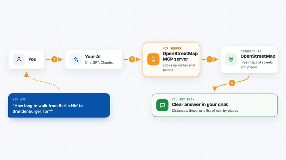
You type a question in plain words, like how far it is from one address to another. Your AI passes that question to this helper program. The helper then talks to the free OpenStreetMap services on the internet, which know about streets, paths and places all over the world. Those services send back distances, times, coordinates or lists of nearby places. Your AI turns that into a normal answer in your chat window.
 Click to zoom
What you can do with it
- Find the coordinates of any place name or address
- Get walking, driving or cycling distance and time between stops
- Work out the best order to visit several places in one trip
- See how far you can travel in 15 minutes by foot, bike or car
- Find nearby cafes, pharmacies, parking spots or other places
- Look up opening hours, phone number and website of a place
- Suggest a fair meeting point for two to eight people
Try asking your AI
- “How long does it take to walk from Berlin Hauptbahnhof to Brandenburger Tor?”
- “Find pharmacies within 500 meters of 52.52,13.405”
- “What is the best order to visit these five addresses by bike?”
- “Where should four people from different parts of town meet for lunch?”
What it gives back to you
You get back clear answers in your chat: distances in kilometers, times in minutes, coordinates, or a list of nearby places with their names and how far away they are. For routes with several stops, it can also show the order to visit them in. Some answers come with a link to open the location on the OpenStreetMap website. Nothing is changed on the map itself, because all the tools only read information.
Before you start
What you need
- The Claude desktop app, Claude Code, or another AI tool that supports MCP servers
- Node.js version 22 or newer installed on your computer
- An internet connection
Good to know
The map information comes from OpenStreetMap, which anyone can edit, so treat names and details as helpful but not official.
Install it with your AI
Add OpenStreetMap MCP server to your AI, no technical skills needed
You don't install anything by hand. You copy one prompt, paste it into an AI that can work on your computer, and it checks, installs and connects the server for you, asking you when it needs something.
Sign in to get the install prompt
Members get a ready-made prompt that lets the Claude desktop app check OpenStreetMap MCP server, install it and connect it for them, step by step. You don't need any technical skills: you copy, paste and answer a few questions. Your connected AI can also find and install any of the 4,361 MCP servers here for you.
Who it's for
Anyone who plans trips, visits clients, organizes meetups or just needs to know how far away something is, without being technical.