MCP server · Coding
QGIS MCP server
by jjsantos01
Let your AI create QGIS maps, add layers and run map tools for you.
This is a helper that connects the QGIS mapping program on your computer to your AI assistant. Once it is set up, you can just describe what you want in plain words, and your AI will do it inside QGIS for you. It is handy for anyone who makes maps but finds clicking through menus slow.
What is an MCP server? The 30-second version
On its own, your AI can only chat. An MCP server is a small helper program that gives your AI a new skill or a connection to another app. This one connects your AI to QGIS, the free mapping program, so the AI can open projects, add map layers and run map tools when you ask. You stay in charge; the AI just does the clicking for you.
What this MCP server does
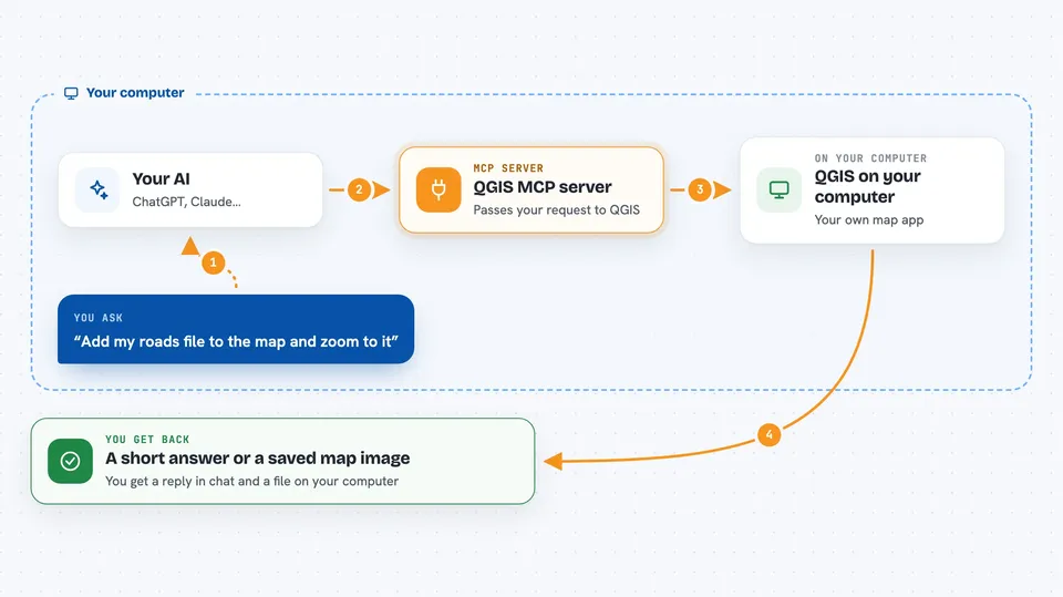
You type a request in your AI chat, like making a new map or adding a file of map data. The AI passes that request to this helper, which talks to a small add-on running inside QGIS on your computer. QGIS does the actual work, such as loading a layer or running a map tool. The result comes back to your chat as a short answer, a list of layers, or a saved image of the map.
 Click to zoom
What you can do with it
- Create a new QGIS project and save it where you want
- Add vector or raster map layers from files on your computer
- List the layers in your current project and remove ones you no longer need
- Zoom the map view to a specific layer
- Run QGIS processing tools, like finding the centre points of shapes
- Save a picture of your current map view
- Run small bits of Python code inside QGIS when you need something custom
Try asking your AI
- “Create a new QGIS project and save it to my Documents folder as mymap.qgz”
- “Add the shapefile at C:/data/roads.shp as a layer called Roads and zoom to it”
- “List all the layers in my current project”
- “Render the current map view to C:/data/mymap.png”
What it gives back to you
You get short answers in the chat, like a confirmation that a project was created or a layer was added. When you ask for a list, you get a list of layer names and details. When you ask for a map picture, it is saved as an image file on your computer, and the AI tells you where it went. If something fails, you get a plain message about what went wrong.
Before you start
What you need
- QGIS 3.x installed on your computer
- The Claude desktop app
- Python 3.10 or newer
- The uv tool installed (a small helper for running Python programs)
Good to know
The execute_code tool can run any Python command inside QGIS, so only use it when you trust what the AI is about to run.
Install it with your AI
Add QGIS MCP server to your AI, no technical skills needed
You don't install anything by hand. You copy one prompt, paste it into an AI that can work on your computer, and it checks, installs and connects the server for you, asking you when it needs something.
Sign in to get the install prompt
Members get a ready-made prompt that lets the Claude desktop app check QGIS MCP server, install it and connect it for them, step by step. You don't need any technical skills: you copy, paste and answer a few questions. Your connected AI can also find and install any of the 4,361 MCP servers here for you.
Who it's for
People who make maps or work with location data, like GIS analysts, planners, students and researchers, who want to save time in QGIS.