MCP server · Research
floodwise MCP server
by qinisolabs
Look up the official long-term flood-risk band for any England postcode, straight from your AI chat.
floodwise is a small helper that lets your AI look up the real flood-risk band for a postcode in England. The data comes from the Environment Agency, not from the AI's memory, so you get a real answer instead of a confident guess. It is handy if you work with addresses, property, insurance, or planning and want a quick check.
What is an MCP server? The 30-second version
On its own, your AI can only chat. It has no way to look up a specific postcode in a government dataset. An MCP server is a small helper program that gives your AI a new skill or a connection to a service. floodwise is that helper here: it connects your AI to the Environment Agency's postcode flood-risk data, so the AI can look up a postcode for you when you ask.
What this MCP server does
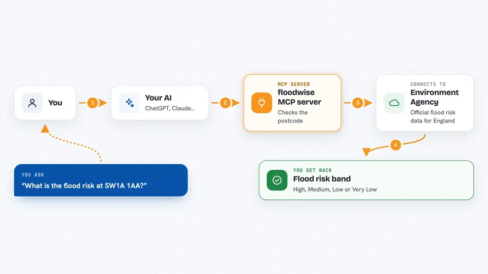
You ask your AI something like what is the flood risk at a certain postcode. The AI passes that postcode to floodwise. floodwise checks the postcode against the Environment Agency's official dataset and finds the long-term risk band for the area. It sends the result back, and your AI shows it to you in the chat. If the postcode is not in the England dataset, it says not found instead of making something up.
 Click to zoom
What you can do with it
- Look up the long-term flood-risk band for an England postcode
- See how many addresses in that postcode are in the high, medium, and low risk bands
- Check the separate groundwater indication for that postcode
- Confirm whether a postcode is well formed before you use it
- Split a postcode into its outward and inward parts
- Get an honest not found answer for postcodes outside England
Try asking your AI
- “What is the flood risk at SW1A 1AA?”
- “Check the flood-risk band for postcode EC1A 1BB”
- “Is EH1 1AA a valid UK postcode, and what is the flood risk there?”
- “How many addresses at M1 1AE are in the high flood-risk band?”
What it gives back to you
You get back a short answer in the chat: the postcode, whether it was found, and the long-term risk band such as High, Medium, Low, or Very Low. It also shows counts of addresses in each risk band and a separate groundwater indication. For a postcode outside England, or one that is not in the dataset, you get a clear not found message instead of a made-up number.
Before you start
What you need
- The Claude desktop app or another AI app that supports MCP servers
- Node.js installed on your computer (the free program that runs npx)
Good to know
This covers England only, is area-level rather than for a specific building, and shows long-term risk, not a live flood warning, so do not treat it as insurance, surveying, or professional advice.
Install it with your AI
Add floodwise MCP server to your AI, no technical skills needed
You don't install anything by hand. You copy one prompt, paste it into an AI that can work on your computer, and it checks, installs and connects the server for you, asking you when it needs something.
Sign in to get the install prompt
Members get a ready-made prompt that lets the Claude desktop app check floodwise MCP server, install it and connect it for them, step by step. You don't need any technical skills: you copy, paste and answer a few questions. Your connected AI can also find and install any of the 4,361 MCP servers here for you.
Who it's for
People who work with England addresses, property, insurance, planning, or local research and want a quick, honest flood-risk check.